Now two years after completing New Zealand’s Te Araroa, I find I still have quite mixed feelings about the trail.
Of course, I’m glad I hiked Te Araroa. After completing the Triple Crown of Hiking in the US, the TA was my first epic-length long-distance hike outside of the US.
There’s definitely lots of amazing parts to Te Araroa, but also a lot of negatives. Especially after letting the trail sit in my mind after completing it, I’m still not sure how highly I would rate the trail. But I want to focus first on what I liked about Te Araroa, because criticism aside, there’s plenty of good things to highlight.
The Highlights
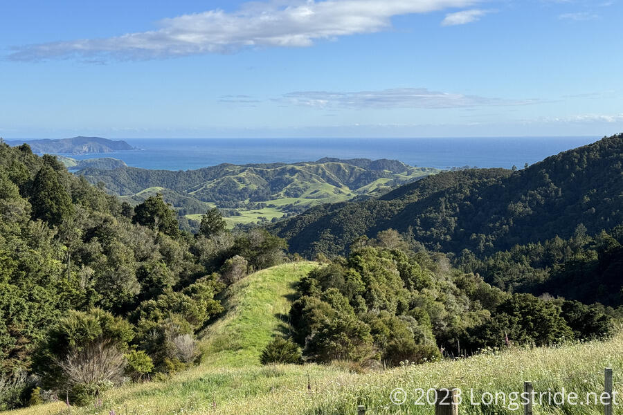
Although a lot of road walking was involved, the Far North District of the Northland Region had a combination of stunningly green scenery and rolling hills, and the somewhat inaccurately named Ninety Mile Beach that together were an incredible way to start Te Araroa.
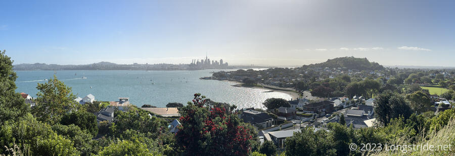
While walking through cities is often not exciting, the walk back “home” to Auckland did have a certain emotional resonance. (My partner had been living in Auckland for a little over a year before we started hiking the TA, and I’d spent a couple of months there in early 2023 before hiking the TA.) Walking the entire length of a city we knew somewhat well was interesting, particularly since we could very clearly see how the city changed as we went further south. The fancy, ritzy cliff-side houses on the northern suburbs and North Shore gave way to the skyscrapers of the central business district. Going further south, the shops and businesses gradually took on a less fancy, more gritty nature, until eventually, we passed the airport and the southern suburbs, and emerged into the more rural space between Auckland and Hamilton, some of which was clearly on the verge of being overrun by Auckland’s gradual expansion.
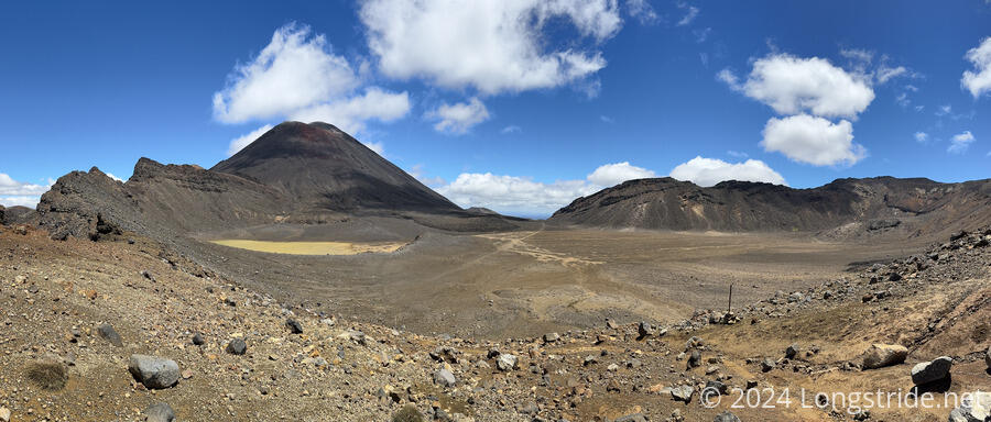
After having to sit out bad weather for a few days, we had the opportunity to hike the Tongariro Crossing on Jan 1, 2024. Normally an incredibly popular hike, with hundreds (or even thousands) of day-hikers each day, a forecast of high winds and bad weather caused the cancellation of the shuttles servicing the point-to-point hike. While still a bit windy, the weather was less bad than forecast, so we got to enjoy the trail with relatively few other hikers, making this a special, and spectacular, way to start off the new year.
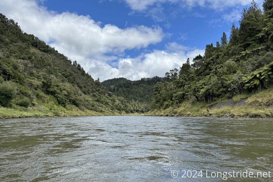
Somewhat unique among long-distance hiking trails, Te Araroa includes a roughly 160 kilometer stretch of canoeing down the Whanganui River as part of the official trail. This was my first time in a canoe for more than a couple of hours, and also my first time having to navigate rapids. Despite rapids with such names as “50-50” (supposedly because you only have a 50% chance of making it through without capsizing), we made the five day journey without once tipping over.
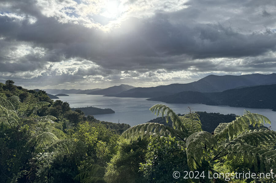
The Queen Charlotte Track was a fantastic way to start off the South Island. On or near ridges along the Marlborough Sounds, the trail gives incredible views of a great many coves and bays.
With the trail on the South Island being a much more backcountry experience, the system of huts on public land managed by DOC (the New Zealand Department of Conservation) was a little reminiscent of my hike of the Appalachian Trail. I only used my tent ten times on the South Island, including a stretch with over a month between uses!
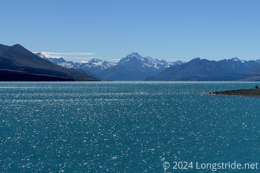
The stretch from Lake Tekapo to Lake Ōhau passed several brilliantly-colored glacial-fed lakes, with the Southern Alps and Aoraki / Mount Cook as their backdrop. As a bonus, I was able to cycle this stretch, turning what would have been a long slog on cycle tracks into a faster-paced and more interesting ride. (This was also the longest and furthest I’ve ever ridden a bike continuously.)
The Lowlights
Though there was plenty to like about Te Araroa, there is also a lot to criticize. In a lot of ways, I think the reality of the trail as it currently exists has not yet caught up with the TA’s ambition and promotion. Largely, the trail’s supporting infrastructure isn’t sufficient to keep up with the number of hikers on the trail.
On the North Island, trail infrastructure is very limited outside of towns. This isn’t too bad north of Hamilton, but in some of the “more remote” parts of the North Island, the trail winds through farmland and along roads between private properties. There aren’t sufficient campsites, leading to hikers having to rely on residents who run official or makeshift hostels out of their homes, garages, or front yards.
Even on the South Island, where there is plenty of wilderness, camping can be quite difficult due to a lack of campsites, official or otherwise. Often, the only place to camp is in the space immediately around a hut. Wild camping may technically be allowed, but that doesn’t matter if there’s no clear flat ground to pitch a tent.
The trail through North Island farmlands is especially of wildly varying quality. There are places where you hike in a person-wide corridor filled with overgrown grass hiding ankle-breaking divots, with an electric fence on one side separating you from an angry looking bull, and a barbed wire fence on the other side “protecting” you from the eroding cliff that drops off steeply into a river.
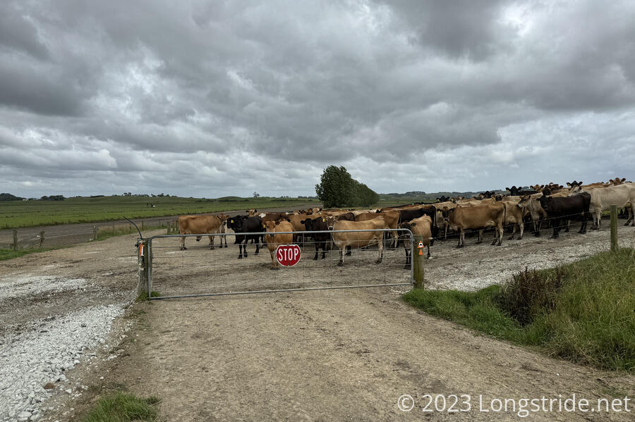
While we are fortunate, and I am grateful, that the trail is even able to go through the farms at all, rather than being routed on highways, it doesn’t make it any less annoying or unnerving. (As it is, the trail has far too much routing along highways and busy roads, some of which actually is outright dangerous.) In some of those areas, signage is a bit sub-par (because they’re working farms, with animals), and the trail is not always clearly indicated, especially when there is tall grass (and paths made by cows or sheep). Especially when hikers are admonished to Stay On The Trail!, there should not ever be a question as to where the trail actually is.
Particularly in the more remote areas of the South Island, trail maintenance often left a lot to be desired. In the Richmond Range, there was a surprising amount of flat-out unsafe trail (with fall-into-raging-rivers consequences) that could have been “easily” ameliorated with some ropes or rebar handholds. Other places had very eroded trail that got visibly worse with each hiker that passed. (I very much did not enjoy the Richmonds, feeling that relative to the reward of its views, the danger and difficulty was too high.)
The dichotomy of trail maintenance sometimes made me wonder what DOC was even thinking. The Puketi Forest apparently had budget for an incredibly long staircase and multi-kilometer gravel path, but the Richmonds couldn’t even get handholds in sketchy sections. (The obvious answer is, the budget goes where there are more people hiking, but the sheer scale of some North Island trail construction compared to a complete lack of simple affordances on the South Island is still weird if you view Te Araroa in isolation.)
The South Island hut system was great, reducing the frequency with which hikers need to set up tents, which reduces the impact to the land near the huts. But many of the huts along the TA corridor are relatively small, generally supporting less than ten people. When there’s a large hiker “bubble”, this isn’t sufficient capacity for TA hikers, let alone for people not hiking Te Araroa who want to use those huts.
Multiple times, I saw other hikers forced out of huts due to lack of space. I got fairly lucky in that regard: only once did I have to sleep on the floor of a hut rather than a bunk, and never in my tent. And that was in 2023/24; I’ve since heard it’s gotten much worse, such that some sections of the TA now suffer from a “race to the hut”, where people get up increasingly early and start hiking while it’s still dark in order to get to the next hut before it’s full.
I think there are three main reasons for many of these problems. First, the TA is a young trail. It opened in 2011, making it only fifteen years old. The trail is experiencing growing pains: there hasn’t yet been enough time to negotiate all the land access and build all the infrastructure needed.
Time will gradually improve the trail. For example, plans are in the works for a bridge over the Whangaehu River south of Whanganui, which will eliminate 32 km of road walk. And the Longwoods Forest, famous for its epically muddy trail, is supposed to soon get a boardwalk through the worst of the boggy areas. Undoubtably, other problem areas will improve in the future as time and money allows.
The second reason is that New Zealand is a small country: it has a total of 5.3 million people. There’s only so much that can be done at a time by a population that small.
In contrast, the United States has 340 million people. In 2025, 16.9 million people, more than three times the population of New Zealand, hiked some part of the Appalachian Trail. The AT is also over 100 years old. While the other Triple Crown trails aren’t that old, they have tax bases and volunteer networks that far surpass what Te Araroa could ever hope to have access to. So with that in mind, I think it’s actually fairly impressive that, despite my complaints, Te Araroa is as established and in as good a condition as it is.
Misconceptions
The third main reason for the state of the trail is that what it means to hike (really, tramp) in New Zealand is very different than in the US (with its well-established wilderness trails) or in Europe (with ancient networks of town-to-town trails). In New Zealand, unless a trail is popular enough to warrant a high level of infrastructure, tramping is more often a travel through wilderness, and you’re expected to take the land as it is, lack of switchbacks or proper drainage or safety handholds included.
If your idea of New Zealand comes from the fantastic scenery in the Lord of the Rings and The Hobbit films, and you expect Te Araroa to be representative of that, the trail will be a massive let-down. Little of the epic scenery from LOTR, including the best of New Zealand, is actually on the TA. On the North Island, south of Auckland, the TA largely cuts down the western side of the island, skipping the Coromandel peninusla and the entire eastern part of the island, where there is plenty of fantastic scenery. On the South Island, the TA skirts, but does not really go through, the Southern Alps, and bypasses the Fiordlands entirely.
Not surprisingly, a lot of TA hikers take diversions from the trail, skipping less ideal sections to explore other parts of New Zealand. Some hikers skip the large amount of road walking on the North Island entirely. I felt this contributed to a lack of trail culture and camaraderie on the TA that I experienced on the Appalachian, Pacific Crest, and Continental Divide trails. When hikers don’t have shared experiences and ample opportunity to congregate (especially on the North Island, at the start of the trail for southbounders), it makes it harder to form the type of connections that come more easily on other trails.
But on that note: I found that no small number of hikers on the US Triple Crown trails were there to escape something. On the TA, most hikers seemed to be there to appreciate New Zealand. And on balance, I think that’s usually a healthier reason to choose to be somewhere.
To Wrap It Up
Despite the mixed bag and complaints, Te Araroa was a great experience for me. Nearly everyone I interacted with was friendly or helpful. And while the TA often didn’t match the epic landscapes I’ve seen on other hikes, it still had plenty of excellent scenery to offer.
But if your experience with hiking is on US trails, I would caution that the TA is not like any of the US Triple Crown trails, and treating it as if it is is a great way to be disappointed. The TA is not comparable to those trails. It is its own thing, and it’s best to keep that in mind. It’s a great trail to hike, but only if you set aside whatever expectations you might have.